This page contains two chapters from the book, D-Day: The prelude. The drama. The aftermath by Torsten Granov. Get the Amazon Kindle edition here or the iPad edition here (with videos). Back to tour of Normandy (click here).
Chapter 6. Operation Overlord
Preparations for an invasion on the Continent had already begun in the spring of 1942 and the raid on Dieppe had major consequences for the invasion planning. The great respect held by the British for the German army resulted in a wish for the latter to be steadily depleted and worn down through operations in, for example, Italy and the Balkans. It was thought that this strategy would save soldiers’ lives, rather than embarking on a massive attack on well-fortified German positions along the French coast. It was not a strategy which was accepted by Britain’s allies, the United States and the Soviet Union.
At a conference between Churchill and Roosevelt and several Allied military leaders, held in Casablanca in December 1942, and later at a conference in Teheran in November 1943 involving Stalin, Churchill and Roosevelt, it was decided that the invasion of France should take place in the spring of 1944, in April or May.
The invasion plan was given the codename Overlord and an American, General Eisenhower, was appointed as its commander-in-chief. His second in command was General Montgomery, who was to be the commander-in-chief of the land forces. Admiral Ramsey was to be head of the naval forces and Air Marshall Leigh-Mallory was to lead the air forces. The three leaders of the land, naval and air forces were all British.
Ahead lay a phase of planning and preparation during which all major significant problems relating to the mounting of the invasion had to be resolved and all important decisions had to be taken.
The size and composition of the invasion force had to be decided upon. The many practical problems involved in assembling a force of more than 2 million men had to be addressed. Solutions had to be found to the logistical problems of supply both before and after the invasion. The entire invasion force had to be trained and made to function together and the final decision had to be made about the actual location for the invasion.
Allied planners were faced with the largest single military operation in history: An operation, which would be decisive for the outcome of the war and, as a consequence, the future of the entire world.
One of the requirements for the success of the invasion was the availability of adequate troops and equipment. The United States had begun to build up its army and was in the process of turning over domestic production to the manufacture of all the different kinds of munitions which would be required. But all of these had to be transported to Britain and in 1942 and early 1943 German U-boats were sinking large numbers of Allied ships in the Atlantic. First when the U-boat war was won, as happened in the course of 1943, could the supplies be shipped to Britain in the quantities, and at a pace, necessary for the invasion.
One of the first decisions which had to be made was where the invasion should take place. After a good deal of deliberation, the choice fell on the northern coast of Normandy which, as a consequence, was to become the scene of the largest military operation in world history.
Why Normandy?
The number of possible landing places for the Allied invasion of the Continent was limited. It was obvious that Britain must be the starting point in the assembly of the invasion fleet. Only Britain could accommodate the enormous numbers of troops and the huge amounts of equipment which had to be brought together before the invasion could be launched. It was also obvious that the distance between the points of embarkation and the location for the invasion should be as short as possible. The greater the distance, the greater the risk of the Germans discovering the invasion fleet, and also the greater the German opportunities for implementing counter-measures against the invading army.
The shortest distance between Britain and the Continent is between Dover and Calais. But as this was the most obvious place for an invasion and, consequently, the most fortified and the place where the element of surprise would be least, the Allies chose not to consider the Calais area as a possibility.
Other options for the establishment of a second front against Germany
There was also the possibility of opening up a second front in Southern France or Northern Norway, and both options were considered seriously before it was decided that the actual and decisive landing should take place in France, in Normandy. Other immediate alternatives included The Netherlands or the west coast of Denmark. Denmark was discounted due to the distance from Britain; it lay beyond the combat range of British fighter aircraft. The coast of The Netherlands was similarly rejected, again due to the distance, but also because of the very heavy fortifications and the possible defensive advantages afforded to the Germans by the landscape, as it would be easy to flood the low-lying areas behind the coast. Another alternative also given serious consideration was the southern coast of Brittany, but this too was abandoned due to the distance from Britain. This location was, however, identified as a possible landing place for a second invasion, should the invasion of Normandy meet with difficulties or grind to a halt.
The advantages of Normandy
The reason for the final choice falling on Normandy was that the northern coast here met a number of the criteria the planners had specified in the light of the Dieppe fiasco. Geographically, the coast has only a few actual cliffs, it mostly consists of sandy beaches with easy access further inland. The area is also so large that it would be possible to launch several landing operations at the same time along a broad front. With the aid of diversionary manoeuvres it was also hoped that the Germans could be led to believe that the invasion would take place around Calais and thereby benefit from the element of surprise. The northern coast of Normandy was also much less heavily fortified than the area around Calais and much more thinly manned. And it lay so far away from Central France that, by the destruction of roads, bridges and railway lines, it could be made difficult for the Germans to bring in reinforcements.
Furthermore, the area lay so close to Britain that fighter aircraft would be able to operate from bases in England and the Allies’ air supremacy could thereby be exploited from the very beginning of the invasion. This superiority in the air also made it possible to prevent or make difficult German troop movements during the day and necessitated their use of camouflage during daylight hours.
An additional argument in favour was that the area to the south of Caen is very low-lying and easily flooded. This meant that if the invasion was only a partial success, and the Germans launched counterattacks, the area could be deluged and the invading forces could entrench in Normandy and defend themselves behind these watery areas.
No harbour
The northern coast of Normandy’s greatest disadvantage was its lack of a harbour or port. The solution was, in the first instance, to manufacture two prefabricated harbours in Britain and tow them to the Normandy coast immediately following the launch of the invasion and quickly assemble them in situ. As there would be a need for a harbour in the longer term, part of the invasion plan concentrated on capturing the major harbour in Cherbourg.
The choice of Normandy shows the great importance of Dieppe. Lessons had been learned and the risks which became obvious at Dieppe were avoided.
Wind, weather and tide
Allied and German deliberations on conditions for the invasion
Once Normandy had been chosen as the scene of the invasion, the planners faced a series of problems which had to be resolved and a number of questions for which answers had to be found. Where, precisely, should the invasion take place? At what time of day should it be launched? How could the problems arising from a tidal range of 4 m – between high and low water – be solved? Should the landing be at high or low tide? Should it be at full moon or when there was no moon?
Each answer to these questions, and the decisions that were made, could mean the difference between life and death for thousands of men. Just one wrong decision could bring about the failure of the entire operation.
Low or high tide?
A decision had to be made in the planning phase about whether to land at high or low tide. The advantage of landing at low tide was that all the German defences located on the beach would be visible; at high water these would be hidden by water. The disadvantage was that, because the invasion beaches were generally relatively flat, there was, in some instances, a several hundred metre difference in their width at high and low tide. If the decision was made to go in at low tide, this would mean that the landing craft would not be able to sail in close to the coast and both soldiers and vehicles would have to cross a broad beach with no cover. It would extend the time between leaving the vessels and finding cover and was, as a consequence, more dangerous for the invading troops. This situation was the reason that the German commander-in-chief for the Atlantic Wall, Field Marshall Rommel, believed the Allies would land at high tide. In doing so, the invasion’s landing craft would be able to sail closer to land, but would also risk being damaged or blown up by the mines or other obstacles which the Germans had installed on the beach and which were hidden at high water. As the Germans were convinced that the invasion would take place at high tide, all the German guns were trained on targets which would be visible at high water.
The deliberations of the Allied planners resulted in a decision to land at low tide.
When to go ashore?
It was obvious to both the Allied and the German planners that the landing should take place at dawn so the invasion fleet was hidden by darkness for as long as possible, but that it was light when the troops came ashore. For the Allies, it was therefore a matter of finding a day when low tide coincided with sunrise. As the Germans assumed the invasion would take place on a day when sunrise coincided with high tide, they calculated a series of wrong dates as possibilities for the invasion.
The date?
The Allies wanted the days during and after the invasion to be as long as possible, so it was decided that the operation should take place after 15th May. Most storms in the area normally occur in spring and this consideration also influenced the decision with respect to the date for the invasion towards later in the year.
The invasion could under no circumstances take place before the end of April because this was the earliest point at which the invasion forces in Britain would be ready for the operation. And, as airborne actions were to begin already on the night prior to the actual invasion, in the interests of the pilots’ navigation and the opportunities for the troops who were landed to find their way, there was a requirement for the operation to take place around full moon.
The first date after 15th May 1944 on which there was a full moon and low tide at daybreak was 5th June: This was fixed as D-Day – the date for the invasion.
The weather
It was obvious to both the Germans and the Allies that the invasion would require relatively good weather. Rain and fog would deprive the Allies of the advantage of air supremacy. Strong wind and rough seas would make it difficult for the many ships involved in the invasion to manoeuvre and navigate and would also represent a threat to the smaller invasion vessels, many of which were not particularly seaworthy. The final decision to launch the invasion would therefore depend on the meteorologists’ weather forecast for the day.
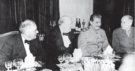
The Teheran Conference – Roosevelt’s birthday
The Allies had enjoyed such success in military actions in 1942 and 1943 that thoughts began to turn towards the end of the war; there was a need for a conference between the Allied leaders. Churchill, Roosevelt and Stalin met in Teheran in November 1943 and it was decided to mount an invasion of France in the course of 1944. This meeting also saw the first discussions of the post-war world. There was no general consensus on Germany’s post-war position, a subject which concerned Stalin in particular.
During and immediately after the war, three conferences were held involving the three Allied leaders. In Teheran in November 1943, at Yalta in January 1945 and at Potsdam in August 1945, after the war was over in Europe.
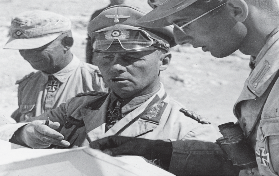
In February 1941, the Germans sent an army under the command of General Erwin Rommel to North Africa, where Italian troops were hard pressed by the British. Rommel secured several major victories despite his numerically inferior troops. Rommel’s success threatened the British Empire which was dependent on free access to the Suez Canal. When the Africa Corps was eventually halted at El Alamein by British forces under General Montgomery, the Germans were only about 100 km (60 miles) from the Suez Canal. Rommel was often at the forefront of the advances and was always in contact with the foremost units. He enjoyed major successes during the campaign in France in 1940, and was Hitler’s favourite general, but was not particularly well-liked among his fellow army officers. He was, however, very popular with ordinary soldiers and the German people. Montgomery refers to Rommel with great respect in his memoirs. When German defeat became imminent in North Africa, Rommel was replaced by a less well-known general who had to take responsibility. In November 1943, Rommel was appointed commander-in-chief of the Atlantic Wall.
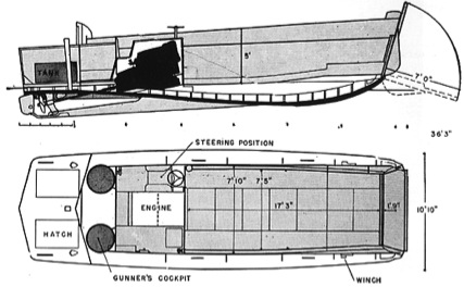
Layout drawing of the American landing craft, the “Higgins boat” that was developed by Andrew Higgins, based on his experience from the Louisiana swamps. More than 20,000 were produced during the war. Most Higgins boats were produced in port cities in the southern United States.
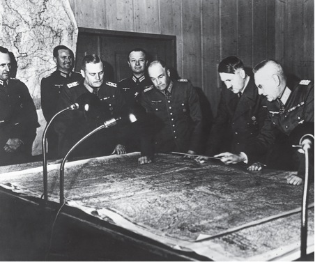
The Führer at the chart table in Wolfschantze, Eastern Prussia.
Around the table stand Wilhelm Keitel, Walter von Brauchitsch, Hitler and Franz Halder.
Hitler had taken over supreme command of the war. He had no military training apart from his experiences as a corporal during World War I. He had extensive detailed knowledge of military matters, an excellent memory and good intuition. When the war began to go badly, he listened less and less to his generals and advisors and dismissed bad news as defeatism. An episode described in Gilles Perrault’s book: ‘The Secret of D-Day’, from the preparation of the daily staff conference in Wolfschanze, goes some way to explaining some of the, at times, inappropriate decisions made by the Führer: “In the map room, Vice Admiral Bürckner of the Abwehr is completing his report on the situation on the eastern front. His assistants are shifting little flags around on the operations map. There are red flags to represent Russian divisions and blue ones to represent German divisions. Bürckner frowns as he watches them. Now and then he grunts:”Ach! Don’t put so much red on the map!” And his men, either from discipline or indifference, put a few Russian divisions into their pockets. It would not do to upset the Führer, and a rash of red flags always throws him into a rage.”
Chapter 7. The Atlantic Wall
The Atlantic Wall was the rather resplendent name given by the Germans to the series of military bases, emplacements, bunkers, machine-gun positions etc. which had been positioned along the entire west coast of Europe in order to defend the Continent against invasion.
The Atlantic Wall extended from Norway, through Denmark, Germany, The Netherlands and Belgium to France and on to the Spanish border. In German propaganda it was portrayed as an unbroken chain of major bunker complexes cast in concrete, with large guns linked by trenches and with small gun emplacements and machine-gun nests in between. The propagandists succeeded in making an impression on the people of Germany and the occupied territories – and also on the Allies. Montgomery in particular had great respect for the Atlantic Wall.
Apart from a few heavily-fortified places, such as around Calais and a small number of locations along the north coast of Normandy, the fortification of this huge stretch of coast was much more modest than the impression given by the propaganda. Only where the danger of invasion was greatest, on the French coast opposite SE England, had obstacles to any great extent been positioned on the seabed and on the shore.
In most places along the Atlantic Wall defensive measures between the military strongholds were limited to minefields.
From the decision being taken in 1942 to build fortifications along the entire length of the coast and until Field Marshall Rommel became commander-in-chief of the Atlantic Wall in November 1943, work progressed relatively slowly. Rommel engaged energetically in the project and the Atlantic Wall was extended at a rapid pace, in direct competition with the assembly of the invasion force that was underway in Britain.
However, on 6th June 1944, a great deal of work still remained to be done on the Atlantic Wall in Normandy, and the work which was in progress would have reinforced fortifications in some of the places where the Allies landed. The guns at Point du Hoc, so feared by the Allies, had yet to be installed.
Where the Atlantic Wall was best developed and best manned, such as at Omaha Beach, it proved to be fairly effective and could, under more favourable circumstances, have hindered the landing on the beach. Where the defences were less well developed, such as at Juno and Gold Beaches, they had only a limited effect on the troops landing there.
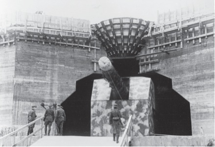
The Atlantic Wall.
Work on the fortifications along the Channel and Atlantic coast was begun by Germany shortly after the defeat of France in 1940. These fortifications took the form of smaller coastal defence installations at exposed points and large gun emplacements at Calais, from where, using large guns, it was possible to bombard the area around Dover. After 1942, these facilities became part of the Atlantic Wall, the German term for the fortifications constructed along the Atlantic coast, from the Spanish border to Northern Norway. The actual building work comprised Operation Todt, named after engineer Fritz Todt who, until his death under suspicious circumstances in 1942, was head of the organisation responsible for carrying out construction work for the German army all over Germany and in the occupied territories.
After Todt’s death, Hitler appointed Albert Speer as his successor. Work on the fortifications was carried out by soldiers, prisoners of war and both volunteers and ordinary labourers from the occupied countries. Despite occasional sabotage and the relative inexperience of the workers, the building works have proved to be surprisingly durable and can still be seen everywhere along the coasts where they were constructed. Some of the local workers on the bunkers were members of the resistance movement and they reported on the structures and fortifications to the Allies, who thereby acquired a good knowledge of the defences. Many of the artillery positions had guns captured during the war or removed from for example the Maginot Line or from Czech forts in the Sudeten Mountains. This meant that it was impossible to standardise ammunition, as every gun had to have a particular type, depending on manufacturer, calibre etc. This made the supply of shells complicated and ineffective.
The finished bunkers were, to a large extent, manned by troops who could not be deployed elsewhere in the German army: invalids, the old or those who for one reason or another were seen as being unsuitable for service in the regular army. The complement also included volunteers from the Soviet Union. Only a few sections were manned by fully effective troops. The German military command was aware of the poor motivation of the foreign troops. An officer fromRommel’s staff expressed it as follows: “What can you expect from Russians fighting for the Germans against the Americans in France?”
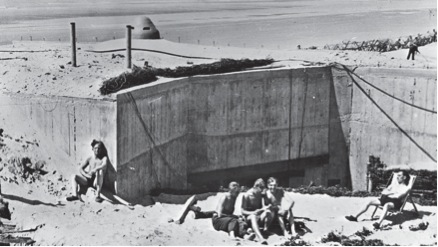
The construction of the gun battery Lindemann at Cap Gris-Nez near Calais in 1942. From here, it was possible to hit targets in Southern England on the other side of the Channel. The battery became part of the Atlantic Wall and constituted one of the heavy defensive positions.
In front of the fortifications there were tank traps, trenches and barbed wire, and in front of the minefields between the fortifications, barbed-wire barrages were erected along the beach, mines were laid in the sand and various obstacles were placed on the seabed; these became covered with water and were invisible at high tide. Many of the obstacles had mines attached, which exploded if a vessel struck. The beach obstacles were not of equal density everywhere.
